
Top Menu

NASA logo
TAP

Archive | Air RSS

EPOCH

EPOCH logo

East Pacific Origins and Characteristics of Hurricanes (EPOCH)


Over the past five years, tropical activity in the East
Pacific has increased, while decreasing in the Atlantic Basin. In addition, during El Niño years, warmer than average sea surface 5 temperatures further increase
the likelihood of tropical cyclone formation in the East Pacific. EPOCH plans to fly the AV-6 GH aircraft with the EXRAD radar, the High Altitude MMIC Sounding Radiometer (HAMSR), and the NOAA AVAPS dropsonde system to investigate genesis and rapid intensification (RI) of an East Pacific hurricane by measuring both the environment and interior structures.

EPOCH will develop the EXRAD radar from a Technical Readiness Level 6, with respect to the Global Hawk, to a Technical Readiness Level 8 at the end of the project with a successful flight of the radar, radiometer, and dropsondes over an East Pacific hurricane.
Over the past five years, tropical activity in the East
Pacific has increased, while decreasing in the Atlantic Basin. In addition, during El Niño years, warmer than average sea surface 5 temperatures further increase
the likelihood of tropical cyclone formation in the East Pacific. EPOCH plans to fly the AV-6 GH aircraft with the EXRAD radar, the High Altitude MMIC Sounding Radiometer (HAMSR), and the NOAA AVAPS dropsonde system to investigate genesis and rapid intensification (RI) of an East Pacific hurricane by measuring both the environment and interior structures.

EPOCH will develop the EXRAD radar from a Technical Readiness Level 6, with respect to the Global Hawk, to a Technical Readiness Level 8 at the end of the project with a successful flight of the radar, radiometer, and dropsondes over an East Pacific hurricane.


GeoCarb

Geostationary Carbon Cycle Observatory (GeoCarb)

https://www.ou.edu/geocarb

Paving the Way for Future Earth Science Missions

GeoCarb’s mission is to study Earth’s carbon cycle: The exchange of carbon among land, ocean, plants and animals, via processes like respiration and photosynthesis from the biosphere and burning fossil fuels. Carbon is the foundation of all life on Earth and understanding its circulation throughout the Earth system is crucial for understanding ecosystem health and services, ocean biodiversity and acidity, crop production, climate change and much more.

“Because the GeoCarb Mission provides persistent daytime measurements from a geostationary orbit of the concentration of the three important carbon gases: carbon dioxide, methane, and carbon dioxide every day under changing conditions at fine spatial scales that it will provide the information needed for breakthrough investigations into the global carbon cycle. In sum, GeoCarb will provide the basis for a transformational improvement in our understanding of the carbon cycle, and it will demonstrate an effective approach to monitoring CO2 and CH4, the two most important greenhouse gasses that is synergistic with greenhouse gas measurements from low Earth orbit by missions such as OCO-2, OCO-3, GOSAT, and GOSAT-2.” – Berrien Moore, GeoCarb Principal Investigator

GeoCarb will focus on two aspects of the carbon cycle. By measuring the daily concentration of carbon dioxide, methane and carbon monoxide over North and South America, GeoCarb will track changes in these gases over time, yielding insights into where carbon is being absorbed or released into the atmosphere. The mission will also measure solar-induced fluorescence – a faint red or infrared glow emitted by plants during photosynthesis. Together, these measurements will give scientists a clearer picture of how plants absorb and release carbon as they “breathe” during daily photosynthesis – and how this process is changing over time.

GeoCarb’s instrument is a spectrometer, which measures the wavelengths of incoming light to determine composition of gases and other atmospheric state variables. GeoCarb’s four measured wavelength regions allow it to measure the three greenhouse gases (carbon dioxide, methane and carbon monoxide), as well as oxygen, which helps the team calculate the mixing ratio (column concentrations) of gases in the atmospheric column. The channel used to obtain oxygen concentrations also procies a measure of solar-induced fluorescence and other atmospheric characteristics. Understanding the role of plant photosynthesis in the carbon cycle will help scientists predict how atmospheric carbon concentrations could affect climate and other Earth systems in the future.

GeoCarb’s mission is to study Earth’s carbon cycle: The exchange of carbon among land, ocean, plants and animals, via processes like respiration and photosynthesis from the biosphere and burning fossil fuels. Carbon is the foundation of all life on Earth and understanding its circulation throughout the Earth system is crucial for understanding ecosystem health and services, ocean biodiversity and acidity, crop production, climate change and much more.

IMPACTS

IMPACTS

Investigation of Microphysics and Precipitation for Atlantic Coast-Threatening Snowstorms (IMPACTS)

New NASA research project employs an impressive array of technology to discern how and why intense bands of snow form in winter storms in order to supply forecasters with data to improve predictions of severe winter snowfall.

IMPACTS is carrying out several major field campaigns that will study how snow bands develop and grow in hazardous East Coast snowstorms, something that has not been the focus of a major research campaign in 30 years! The US East Coast has many large cities and population centers, so the snow from these snowstorms can have a big societal impact on transportation, commerce, and public safety. The data that IMPACTS collects will be used to improve how we forecast snow. Heavy snow falls from long narrow “snow bands” within storms. The unevenness of the snow bands within the storm is what makes predicting snowfall amounts so difficult. Which storms have strong snow bands and which storms do not? Can we measure snowfall from these narrow snow bands from space? Can we predict the location of the most intense snowfall? IMPACTS will help us find out! Better predictions mean communities can be proactive in protecting populations from oncoming hazards and disruptions.

“I have loved watching clouds and the sky for as long as I can remember. I have always loved doing outdoor activities such as skiing, hiking, biking and gardening, and understanding the weather, clouds and processes that create the rain and snow help me decide when and where to do those activities. Now as a scientist I not only get to admire the sky and the clouds, but learn about my favorite storms – snowstorms – and learn about them on all scales, down to the processes that make the snow and organize the snow into snowbands.” – Lynn McMurdie

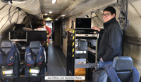
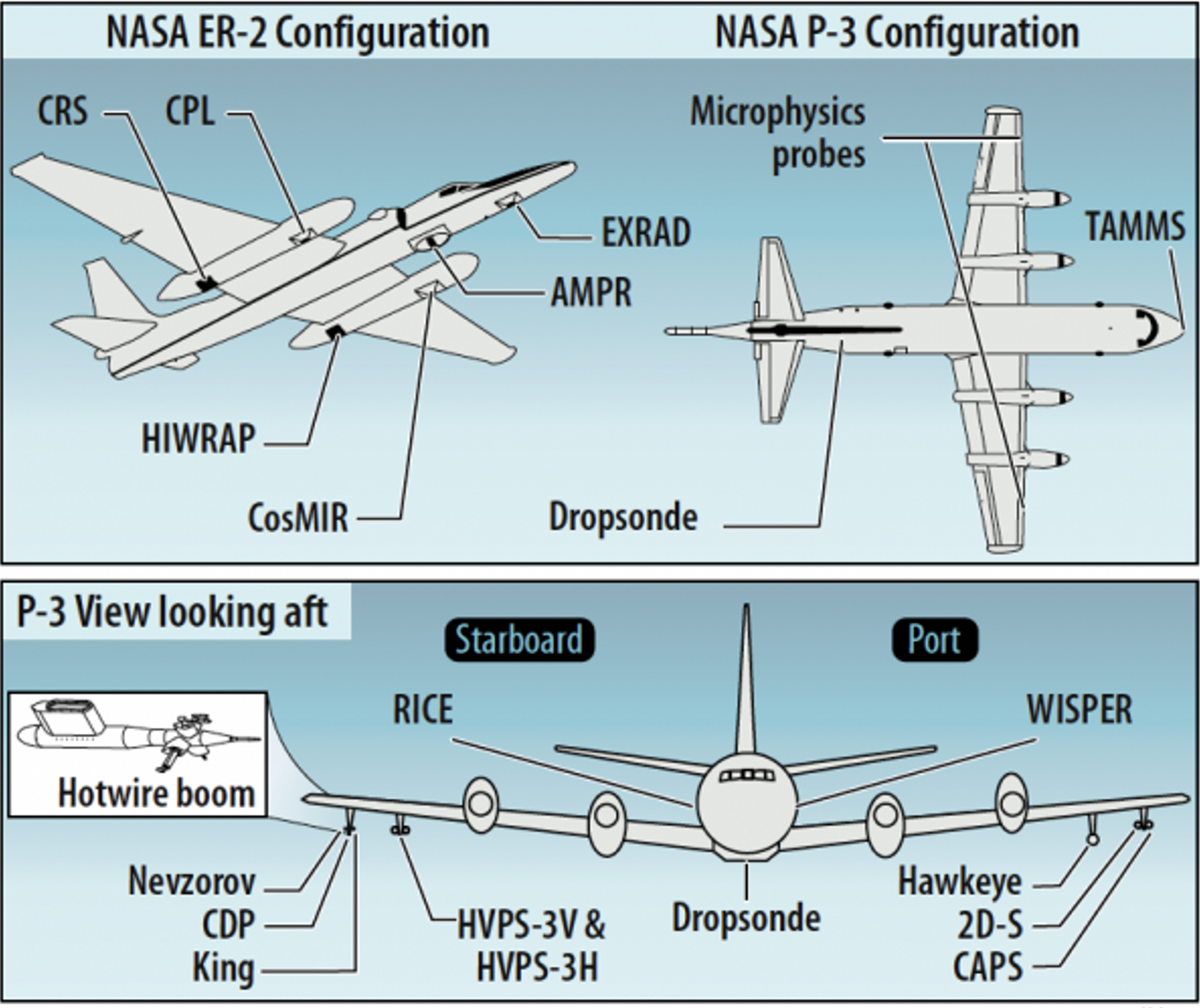
Two NASA aircraft are being used by IMPACTS to go ‘snowstorm chasing’ during three wintertime field campaigns over a three-year period. The NASA ER-2 aircraft flies above the clouds at heights of more than 15 km (9 miles), and carries instruments such as radars, lidars, and microwave sensors that are similar to instruments on satellites now. The second aircraft is the NASA P-3B, and it flies within the snowstorm. The P3B carries instruments that directly sample characteristics of the snowstorm, such as the shapes and sizes of the snow crystals and the environment in which they form. These two aircraft fly coordinated patterns within, above, and around snowstorms as the storms develop, taking data so the scientists can learn exactly how intense snow bands develop within the storms. The data from the remote sensing instruments on the ER-2 aircraft will also help scientists improve our ability to measure snow from satellites.


IMPACTS collects data from a “satellite-simulating” ER-2 and in-situ measurements from a cloud penetrating P-3, augmented by ground-based radar and rawinsonde data, multiple NASA and NOAA satellites [including GPM, GOES-16, and the Joint Polar Satellite System (JPSS)], and computer simulations. The ER-2 and P-3 provide the flight-altitude and long-endurance capabilities and payload capacity needed for the combined remote sensing and in-situ measurements.


Related Projects

New NASA research project employs an impressive array of technology to discern how and why intense bands of snow form in winter storms in order to supply forecasters with data to improve predictions of severe winter snowfall.


[fourcol_six]

Libera

Libera

Libera

https://lasp.colorado.edu/home/libera/

What causes the Earth to cool or warm?

The NASA Libera mission will monitor the flow of radiative energy through the Earth–atmosphere system. This energy drives the motions of the atmosphere and oceans, fuels photosynthesis in plants, forms the protective ozone layer, and sustains all life on Earth. The mission will maintain the decades long data record of observation from NASA’s suite of Clouds and the Earth’s Radiant Energy System (CERES) instruments. Libera, named after the daughter of Ceres in Roman mythology, will fly on the NOAA-NASA Joint Polar Satellite System (JPSS-4) scheduled to launch in 2027.

To meet NASA’s Earth Venture Continuity requirements and to advance the scientific use of Earth Radiation Budget (ERB) data, Libera defines three overarching goals:

  • Provide seamless continuity of the ERB Data Records
  • Develop a self-contained, innovative and affordable observing system
  • Provide new and enhanced capabilities that support extending ERB science goals

Libera will measure solar radiation with wavelengths between 0.3 and 5 microns reflected by the Earth system and infrared radiation with wavelengths between 5 and 50 microns emitted from the Earth system as it exits the top of the atmosphere. The sensor will also measure the total radiation leaving the Earth system at all wavelengths from 0.3 to 100 microns. An innovative additional “split shortwave” channel measuring radiation between 0.7 and 5 microns has been added to enable new Earth radiation budget science.

absorbs more heat than it emits, it warms up; if it emits more than it absorbs, it cools down.

https://lasp.colorado.edu/libera

The NASA Libera mission will monitor the flow of radiative energy through the Earth–atmosphere system. This energy drives the motions of the atmosphere and oceans, fuels photosynthesis in plants, forms the protective ozone layer, and sustains all life on Earth. The mission will maintain the decades long data record of observation from NASA’s suite of Clouds and the Earth’s Radiant Energy System (CERES) instruments. Libera, named after the daughter of Ceres in Roman mythology, will fly on the NOAA-NASA Joint Polar Satellite System (JPSS-4) scheduled to launch in 2027.

To meet NASA’s Earth Venture Continuity requirements and to advance the scientific use of Earth Radiation Budget (ERB) data, Libera defines three overarching goals:

  • Provide seamless continuity of the ERB Data Records
  • Develop a self-contained, innovative and affordable observing system
  • Provide new and enhanced capabilities that support extending ERB science goals

Libera will measure solar radiation with wavelengths between 0.3 and 5 microns reflected by the Earth system and infrared radiation with wavelengths between 5 and 50 microns emitted from the Earth system as it exits the top of the atmosphere. The sensor will also measure the total radiation leaving the Earth system at all wavelengths from 0.3 to 100 microns. An innovative additional “split shortwave” channel measuring radiation between 0.7 and 5 microns has been added to enable new Earth radiation budget science.

absorbs more heat than it emits, it warms up; if it emits more than it absorbs, it cools down.

NAAMES

NAAMES

North Atlantic Aerosols and Marine Ecosystems Study (NAAMES)

Tracking plankton ecosystems to rescue the balance between our sky and ocean
https://naames.larc.nasa.gov/
http://www.journalistatsea.com/

Predict change, manage Earth’s resources and mitigate impacts,…no this isn’t the new SimCity, this is the story of Plankton and NASA’s NAAMES project

Plankton are a vital food source for ocean life and also a key indicator of climate change. Plankton are very sensitive to the temperature of the ocean, so while plankton can impact the climate, the climate can also impact plankton. So, what makes plankton bloom every year, what determines the size and duration of blooms, how do they impact the atmosphere? How will the warming surface ocean temperatures predicted to happen over the 21st century threaten plankton life? Can we change our future with the most productive ocean ecosystem on Earth?

“Our environment is changing. Our climate is changing. Ocean ecosystems are directly linked to climate. It’s hard to imagine that organisms you can’t see make a difference, but they really do.” – Mike Behrenfeld, NAAMES principal investigator, Oregon State University

The NAAMES investigation aimed to find out how the atmosphere and the ocean are intertwined through that ultimate connector, plankton. Gases and aerosols from plankton are released into the atmosphere and become the seeds of clouds. Because marine clouds are an important part of the Earth’s climate, understanding why and how plankton blooms happen, and how they influence clouds, can help us understand the Earth’s climate.

NAAMES consisted of four joint ship and aircraft field campaigns from 2015-2018 that were each performed at a specific time of the year to target different parts of the annual plankton cycle. Ship-based measurements were taken to learn about how much and what types of plankton were present at different times of the year, how fast they lived and died, and how plankton changed the ocean source of gases and aerosols. Measurements from the overflying aircraft were taken to see how aerosol concentrations varied in the overlying air and how efficiently the aerosols seeded cloud formation. The collected data was studied to help us better understand this beautiful relationship between Plankton and clouds. You can predict climate future and societal impacts with NAAMES. Come take a journey with us!

https://naames.larc.nasa.gov/video/NAAMESoverview.mp4

Related Projects

The North Atlantic Aerosols and Marine Ecosystems Study (NAAMES) is a five year investigation to resolve key processes controlling ocean system function, their influences on atmospheric aerosols and clouds and their implications for climate.


TROPICS

TROPICS

Time-Resolved Observations of Precipitation structure and storm Intensity with a Constellation of Smallsats (TROPICS)

Storm trackers observing inside dangerous tropical cyclones to identify storm intensity and structure

https://tropics.ll.mit.edu/CMS/tropics/Mission-Overview

https://disasters.nasa.gov/programs/tropics

NASA TROPICS blog

Imagine if you could peer inside a powerful tropical cyclone (TC). NASA’s TROPICS does and it aims to save lives in the process.

Tropical cyclones have been a source of some of the most devastating natural disasters, claiming countless lives, accounting for more than half of U.S. billion-dollar natural disaster damage events (https://www.ncdc.noaa.gov/billions/summary-stats), and disrupting society. A rise in global temperatures is expected to ramp up storm intensity and rainfall. NASA’s Time Resolved Observations of Precipitation structure and storm Intensity with a Constellation of Smallsats (TROPICS) is expected to launch in 2022 and will address science objectives that will ultimately improve our ability to accurately predict storm strength, giving people more time to evacuate and avoid loss of life. TROPICS is on a mission to find out how TCs form and intensify by measuring 3D temperature, humidity, cloud ice, and precipitation. This mission is critical because close to 60 million people, nearly 1/5 of Americans, live along the East and Gulf coasts. Recent years have seen major landfalling TCs along Atlantic coasts such as Irma, Maria, Michael, and Dorian that can cause significant death and destruction; damage projections suggest a doubling of US economic losses from TCs every ten years!

“TROPICS will observe deep inside cyclones, so we can forecast storms better, improve disaster preparation and ultimately save lives.” -William Blackwell, Principal Investigator, TROPICS

TROPICS provides high‐resolution, rapid updates on storm intensity, size, and precipitation structure. The science team will analyze observations of temperature, moisture, and precipitation at spatial resolutions ranging from approximately 15 kilometers to several hundred kilometers across the sky. Better storm prediction over all ocean basins is provided by six small satellites called CubeSats. They fly in three separate low-Earth orbital planes. Each CubeSat hosts a high‐performance sensor measuring water vapor absorption and precipitation‐sized ice particles. These instruments allow the team to view inside the core of a TC, with high resolution from different angles. The power of this knowledge about how TCs form, how they are maintained, and what makes some more intense than others, will lead to smarter storm predictions and better storm preparation by local authorities and residents.

Related Projects

MIT Lincoln Laboratory, Lunar Laser Communications Demonstration (LLCD); Laser Enhanced Mission Communications Navigation and Operational Services (LEMNOS); Deep Space Optical Comm (DSOC) Psyche Discovery Mission; Transiting Exoplanet Survey Satellite (TESS)
NASA Earth Science Technology Office. MicroMAS, CubeSat in 2018.

Tropical cyclones have been a source of some of the most devastating natural disasters, claiming countless lives, accounting for more than half of U.S. billion-dollar natural disaster damage events (https://www.ncdc.noaa.gov/billions/summary-stats), and disrupting society.  A rise in global temperatures is expected to ramp up storm intensity and rainfall. NASA’s Time Resolved Observations of Precipitation structure and storm Intensity with a Constellation of Smallsats (TROPICS) is expected to launch in 2022 and will address science objectives that will ultimately improve our ability to accurately predict storm strength, giving people more time to evacuate and avoid loss of life.  TROPICS is on a mission to find out how TCs form and intensify by measuring 3D temperature, humidity, cloud ice, and precipitation. This mission is critical because close to 60 million people, nearly 1/5 of Americans, live along the East and Gulf coasts. Recent years have seen major landfalling TCs along Atlantic coasts such as Irma, Maria, Michael, and Dorian that can cause significant death and destruction; damage projections suggest a doubling of US economic losses from TCs every ten years!

Other Air News

See More Air News…

Powered by WordPress. Designed by WooThemes