Top Menu

NASA logo
TAP

Tag Archives | Air

TEMPO Air Pollution Sensor Integrated with Satellite Host

The TEMPO payload rests atop the IS-40e spacecraft.
Credits: Image courtesy of Maxar

An air quality sensor that will dramatically improve the way scientists measure air pollution over North America has been joined with its satellite host.

NASA’s Tropospheric Emissions: Monitoring of Pollution (TEMPO) instrument was integrated with Intelsat 40e by Maxar’s Space Program Delivery team in Palo Alto, California. From its geostationary orbit — a high Earth orbit that allows satellites to match Earth’s rotation — TEMPO will take hourly daytime observations of air quality over an area that extends from Puerto Rico to northern Canada, from the Atlantic to the Pacific, encompassing the entire continental United States.

“Because of the hard work and dedication of the entire TEMPO team including our Maxar, Intelsat, and Ball Aerospace partners, we are excited to have completed this significant step toward launching with the IS40e spacecraft ” said Kevin Daugherty, TEMPO project manager at NASA’s Langley Research Center in Hampton, Virginia. “We are looking forward to completing the instrument integration and spacecraft testing in the coming months bringing us closer to delivery of TEMPO’s critical air quality science.”

Air pollution — including ozone, nitrogen dioxide and formaldehyde, and tiny atmospheric particles called aerosols — can have serious consequences for human health and the environment.

Currently scheduled to launch in 2022, TEMPO will also form part of an air quality satellite “virtual constellation” that will offer a more holistic view of how pollution is transported around the Northern Hemisphere. Ball Aerospace in Broomfield, Colorado built the TEMPO instrument.

Kelly Chance, of the Smithsonian Astrophysical Observatory in Cambridge, Massachusetts, is the principal investigator for TEMPO.

NASA Langley Research Center Last Updated: Dec 1, 2021 Editor: Joe Atkinson

https://www.nasa.gov/feature/langley/tempo-air-pollution-sensor-integrated-with-satellite-host

Continue Reading

NASA Selects New Mission to Study Storms, Impacts on Climate Models

NASA INCUS

NASA has selected a new Earth science mission that will study the behavior of tropical storms and thunderstorms, including their impacts on weather and climate models. The mission will be a collection of three SmallSats, flying in tight coordination, called Investigation of Convective Updrafts (INCUS), and is expected to launch in 2027 as part of NASA’s Earth Venture Program.
NASA selected INCUS through the agency’s Earth Venture Mission-3 (EVM-3) solicitation that sought complete, space-based investigations to address important science questions and produce data of societal relevance within the Earth science field. NASA received 12 proposals for EVM-3 missions in March 2021. After detailed review by panels of scientists and engineers, the agency selected INCUS to continue into development.

“Every one of our Earth science missions is carefully chosen to add to a robust portfolio of research about the planet we live on,” said Thomas Zurbuchen, associate administrator for the agency’s Science Mission Directorate in Washington. “INCUS fills an important niche to help us understand extreme weather and its impact on climate models – all of which serves to provide crucial information needed to mitigate weather and climate effects on our communities.”

INCUS aims to directly address why convective storms, heavy precipitation, and clouds occur exactly when and where they form. The investigation stems from the 2017 Earth Science Decadal Survey by the National Academies of Sciences, Engineering, and Medicine, which lays out ambitious, but critically necessary, research and observation guidance.

“In a changing climate, more accurate information about how storms develop and intensify can help improve weather models and our ability to predict risk of extreme weather,” said Karen St. Germain, NASA’s Earth Science division director. “This information not only deepens our scientific understanding about the changing Earth processes, but can help inform communities around the world.”

Climate change is increasing the heat in the oceans and making it more likely that storms will intensify more often and more quickly, a phenomenon NASA scientists continue to study.
Storms begin with rapidly rising water vapor and air that create towering clouds primed to produce rain, hail, and lighting. The greater the mass of water vapor and air that is transported upward in the atmosphere, the higher the risk of extreme weather. This vertical transport of air and water vapor, known as convective mass flux (CMF), remains one of the great unknowns in weather and climate. Systematic CMF measurements over the full range of conditions would improve the representation of storm intensity and constrain high cloud feedbacks – which can add uncertainty – in weather and climate models.

The principal investigator for INCUS is Susan van den Heever at Colorado State University in Fort Collins. The mission will be supported by several NASA centers including the Jet Propulsion Laboratory in Southern California, Goddard Space Flight Center in Greenbelt, Maryland, Marshall Space Flight Center in Huntsville, Alabama, with key satellite system components to be provided by Blue Canyon Technologies, and Tendeg LLC, both in Colorado. The mission will cost approximately $177 million, not including launch costs. NASA will select a launch provider in the future.

NASA’s Earth Venture Program consists of science-driven, competitively selected, low-cost missions/investigations. This program provides opportunities for investment in innovative science to enhance our capability to better understand the current state of the Earth system and further improve predictions of future changes. The current Earth Venture program include full missions, satellite instruments for flights of opportunity, instruments for Earth science data record continuity, and sustained suborbital investigations.

For more information about NASA’s Earth science programs, visit: https://www.nasa.gov/earth

Press Contacts
Tylar Greene
Headquarters, Washington
202-358-0030
tylar.j.greene@nasa.gov

Continue Reading

Using Satellite Data to Map Air Pollution and Improve Health

NASA scientists will be teaming up with epidemiologists in the agency’s first health-focused mission. With satellite data, they’ll find out how air pollution affects health in cities around the world.

This map illustrates MAIA's multiangle measurement approach
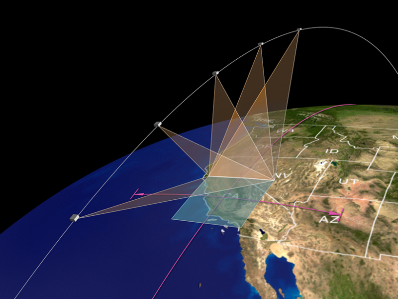
This map illustrates MAIA’s multiangle measurement approach. Credit: NASA/JPL-Caltech

By Jackie Rocheleau 15 April 2021

For epidemiologists studying air pollution, there’s only so much to learn at ground level. So they’ve been taking advantage of aerosol data from NASA satellites to link health outcomes with local air pollution. But only recently have NASA and epidemiologists teamed up to start the space agency’s first mission focused on health.

NASA’s Multi-Angle Imager for Aerosols (MAIA) mission, scheduled for launch in 2022, will combine the expertise of planetary scientists and epidemiologists to answer a question that, before now, has been largely impossible at a large scale: What kind of air pollutant particles is most harmful to human health?

Of the different types of air pollutants, particulate matter (PM), especially particles smaller than 2.5 micrometers (PM2.5), poses some of the most severe health risks. These particles, which primarily form from combustion sources like fossil fuel use and wildfires, vary in composition but are small enough to pass from the lungs into the bloodstream. From there, they can travel all over the body. In the short-term, high PM2.5 levels in the air exacerbate respiratory diseases, whereas long-term exposure can even lead to premature death from heart and lung conditions. Scientists are predicting that climate change could worsen PM2.5 concentrations in some regions, though concentrations could decrease where emission sources are reduced. But even exposures below what regulators consider dangerous are associated with poor health outcomes, like increased mortality in older adults.

“We need to know what about the particles is the most toxic.”

To protect health, scientists need to know which PM components and sources are most harmful. Because PM sources differ between communities, that’s been a problem. “We can’t generalize from a traffic-related-pollution cardiovascular disease or a dementia link in urban areas to a rural area with mostly wood burning,” said Beate Ritz, an epidemiologist and environmental health scientist at the University of California, Los Angeles, and a MAIA coinvestigator.

There’s also the added complication that PM is classified by size, not by kind. “It’s easy to measure the size, not the type,” said Patrick Kinney, Beverly Brown Professor of Urban Health at Boston University. Relative to ground monitoring techniques that record concentrations and sizes of PM, there’s expensive laboratory analysis needed to tease apart particulate types. “We need to know what about the particles is the most toxic,” said Ritz.

Enter MAIA

For the past 20 years, health researchers have been using publicly available data from NASA’s Multi-angle Imaging Spectroradiometer (MISR) instrument to associate air pollution with health outcomes. But “an outstanding question is ‘which particular types and sources of particles are the most harmful?’” said David Diner, a scientist at NASA’s Jet Propulsion Laboratory and principal investigator of both MISR and MAIA.

Data from MAIA could answer that question. Aboard a commercial satellite from General Atomics Electromagnetic Systems, MAIA will circle the globe in low-Earth orbit for 3 years, passing each target study area three times per week at the same local time each pass. To infer the composition of PM2.5, scientists will use the optical properties of particles measured by MAIA: the polarization of sunlight scattered by particles and images of the light at multiple angles in 14 electromagnetic wavelengths spanning from ultraviolet to short-wave infrared. Researchers will map PM2.5 concentrations and composition at the neighborhood level (a resolution of 1 square kilometer) in its 12 primary target cities in North America, Europe, Africa, and Asia. Atmospheric chemistry, spatial, and statistical models will integrate the MAIA data and information from ground-based monitors to output a complete picture of ground-level concentrations of PM and components of PM2.5 in the target areas.

Kinney, a member of the independent scientific oversight committee but not part of the project, is excited about MAIA’s potential. But he’s cautious about taking satellite-based measures at face value. “We still should be careful to understand what the satellites are measuring,” he said. Like other satellite-based instruments, MAIA doesn’t measure particulates themselves, he said, but how they interact with light. (At ground level, scientists use filters to capture actual particles.)

Going Global

Epidemiologists plan to learn which particles are most toxic by linking PM data and population health records in each target area. They’ll study short- and long-term effects of PM exposure and adverse birth outcomes and cardiovascular disease, common issues tightly tied to air pollution.

The data, scientists say, are scalable. “There are many parts of the world where, especially in low- or middle-income countries, there’s just no ground-level monitoring or very, very sparse ground-level monitoring,” said Ritz.

“As time goes on, if we find out which components are driving the health effects, then that’ll help us target interventions.”
“We can do these health outcome studies in countries that do not have electronic medical records,” she continued. “If we can get [birth] data and mortality data in terms of cardiovascular disease, that’s enough to show that there’s an impact from air pollution on these outcomes.”

Ultimately, MAIA’s broad, high-resolution data will allow researchers to understand which communities are most affected by air pollution and what sources are responsible. For the past few years, Ritz has been working with interested scientists in MAIA’s target areas, helping them set up their research infrastructure. “What’s important about MAIA is that it will build these models based on very [data] rich areas, like Los Angeles,” said Ritz. “But then, [researchers] will apply these models to other parts of the country or the world, where ground monitoring doesn’t exist.” That kind of data, Ritz said, could provide momentum for air pollution regulations.

“It could help us understand the disparities in exposure and also understand how to address them by going after the sources that are responsible,” said Kinney. “And as time goes on, if we find out which components are driving the health effects, then that’ll help us target interventions.”

—Jackie Rocheleau (@JackieRocheleau), Science Writer

This story is a part of Covering Climate Now’s week of coverage focused on “Living Through the Climate Emergency.” Covering Climate Now is a global journalism collaboration committed to strengthening coverage of the climate story.

Reposted from original story

Citation: Rocheleau, J. (2021), Using satellite data to map air pollution and improve health, Eos, 102, https://doi.org/10.1029/2021EO157069. Published on 15 April 2021.
Text © 2021. The authors. CC BY-NC-ND 3.0

Except where otherwise noted, images are subject to copyright. Any reuse without express permission from the copyright owner is prohibited.

Continue Reading

ACT America

Atmospheric Carbon and Transport-America
(ACT-America)

https://act-america.larc.nasa.gov/
https://blogs.nasa.gov/earthexpeditions/tag/act-america/

Flying with the gases that impact the climate around you. Making the invisible journey visible.

Track carbon footprints across the sky and through four seasons!
ACT-America is on the hunt for greenhouse gases from our ground and in our air. The project measured both natural and human-based methane (CH4) and carbon dioxide (CO2) to identify how these gases are created, where they go and what absorbs them. Understanding the carbon cycle is powerful knowledge. It means we can predict future climate impacts, develop smarter mitigation strategies, and create fact-based policy. Imagine the benefit from “seeing” where these invisible gases are coming from and where they go.

“ACT-America measurements fill a critical gap in our understanding of the sources, sinks and transport of climate-altering greenhouse gasses. We now see how weather stirs the atmosphere and mixes these gasses across the continent, like a large spoon mixing the cream in your coffee.” – Ken Davis, Principal Investigator

The ACT-America investigation featured five seasonal aircraft campaigns spread over three years, across the eastern and central regions of the United States. Instruments aboard a NASA C-130 and a NASA B-200 aircraft measured greenhouse gasses and indicators of the origins of these greenhouse gases and tracked how weather systems transport them. The aircraft data are part of a growing network of observations that will track the “footprints” of greenhouse gases to enable: 1) policy makers, citizens and industry to understand how their actions are changing the earth’s climate; 2) knowledge of natural gas leaks and awareness of opportunities to minimize these losses; 3) how the earth’s ecosystems contribute to the carbon cycle; and 4) accurate forecasting of future climate. ACT-America’s data can be found here.

https://www.youtube.com/watch?v=c76TfzEJLPo

Related Projects

ACT-America measurements fill a critical gap in our understanding of the sources, sinks and transport of climate-altering greenhouse gasses. We now see how weather stirs the atmosphere and mixes these gasses across the continent, like a large spoon mixing the cream in your coffee.


ACTIVATE

Aerosol Cloud meTeorology Interactions oVer the western ATlantic Experiment (ACTIVATE)

https://activate.larc.nasa.gov/

Riding the marine layer skies looking for aerosol particles – to predict future climate change.

Simulate climate and predict change as it happens!

NASA’s ACTIVATE mission is on the hunt for clouds off the coast over the western Atlantic Ocean! It is looking for answers to help us understand how clouds and aerosols (particles in the air) affect light and heat from the sun. The size and number of cloud droplets within a cloud determines things like how long the cloud lasts, how well it traps heat at the earth’s surface, or how well it reflects sunlight. All of these can have a significant impact on the earth’s climate. One of the largest unknowns in climate change is how the interaction between clouds and aerosols impacts the climate and understanding this is critical towards improving predictions of how future climate will be impacted by human emissions.

“Climate change is one of the most pressing issues we are facing on this planet; it is important for all regions of the world. I have spent my research career studying aerosol particles and the extension to how these particles interact with clouds has opened up a whole new avenue of greater challenges that entices me. The research involves using airborne platforms, which has always been of interest to me as I have always been drawn to airplanes.” – Armin Sorooshian, Principal Investigator

NASA’s ACTIVATE investigation is a five-year project studying how clouds and aerosols interact. Aerosols are very tiny particles that are suspended in the atmosphere and are often the “seed that cloud droplets form around. ACTIVATE focuses on marine boundary layer (MBL) clouds off of the east coast of North America. This region sees a large source of aerosols transported from the US eastern seaboard, making it an ideal area to study these interactions. ACTIVATE is aiming to collect a dataset on aerosol and cloud interactions of unprecedented size and statistics. What’s unique about this investigation? NASA Langley’s King Air and the HU-25A Falcon aircraft are flying together in coordinated patterns to simultaneously gather data from well above the clouds and from directly within the vicinity of the cloud deck itself. These data for both aerosols and clouds will give scientists better understanding as to how these mediums interact and affect our climate.

Related Projects

CALIPSO

NAAMESlogo

NAAMES

ORACLES

ORACLES

NASA’s ACTIVATE mission is on the hunt for clouds off the coast over the western Atlantic Ocean! It is looking for answers to help us understand how clouds and aerosols (particles in the air) affect light and heat from the sun.


Air

INCUS

The Investigation of Convective Updrafts (INCUS) mission will be a collection of three SmallSats, carrying RainCube-like radars with crosstrack scanning and a Tempest-D-like radiometer, flying in tight […]

ACT America

ACT-America measurements fill a critical gap in our understanding of the sources, sinks and transport of climate-altering greenhouse gasses. We now see how weather stirs the atmosphere […]
CloudSat2

CloudSat

NASA launched the CloudSat and the Cloud-Aerosol Lidar and Infrared Pathfinder Satellite Observation (CALIPSO) spacecraft to study the role that clouds and aerosols play in regulating Earth’s […]
DCOTTS

DCOTSS

During the summer, strong convective storms over North America overshoot the tropopause into the lower stratosphere. These storms carry water and pollutants from the troposphere into the […]

EPOCH

Over the past five years, tropical activity in the East Pacific has increased, while decreasing in the Atlantic Basin. In addition, during El Niño years, warmer than […]

GeoCarb

GeoCarb’s mission is to study Earth’s carbon cycle: The exchange of carbon among land, ocean, plants and animals, via processes like respiration and photosynthesis from the biosphere […]
IMPACTS

IMPACTS

New NASA research project employs an impressive array of technology to discern how and why intense bands of snow form in winter storms in order to supply […]
Libera

Libera

NASA has selected a new space-based instrument as an innovative and cost-effective approach to maintaining the 40-year data record of the balance between the solar radiation entering […]
NAAMESlogo

NAAMES

The North Atlantic Aerosols and Marine Ecosystems Study (NAAMES) is a five year investigation to resolve key processes controlling ocean system function, their influences on atmospheric aerosols […]
RaD-X

RaD-X

The NASA Radiation Dosimetry Experiment (RaD-X) high-altitude balloon mission was successfully launched from Fort Sumner, New Mexico on 25 September, 2015. Over 20 hours of science data […]

TROPICS

Tropical cyclones have been a source of some of the most devastating natural disasters, claiming countless lives, accounting for more than half of U.S. billion-dollar natural disaster […]
Fleet Photo

Other Air News

See More Air News…

Atmospheric Tomography Mission (ATOM)

Atmospheric Tomography Mission (ATOM)

Come journey with us and see your impact on the earths’ atmosphere! Can we slow global warming and improve air?

Atom studies the impact of human-produced air pollution on greenhouse gasses and the atmosphere. Pollution changes the air we are breathing right now. This is powerful information for improving our current and future air quality. It helps policy makers with actionable facts and informs modified behavior. We can actually measure our combined impact.​

NASA’s AToM has a flying laboratory aboard the DC-8 aircraft. 42 scientists and operations crew flew with AToM on a 26-day journey from nearly pole to pole and back again. They measured more than 200 gases and airborne particles from the remotest parts of the atmosphere and learned how various greenhouse gases cycle around the world. Atom shows how it’s all one interconnected atmosphere no matter where in the world you are!​

Atom studies the impact of human-produced air pollution on greenhouse gasses and the atmosphere. Pollution changes the air we are breathing right now. This is powerful information for improving our current and future air quality. It helps policy makers with actionable facts and informs modified behavior. We can actually measure our combined impact


[fourcol_six]

CALIPSO

Cloud-Aerosol Lidar and Infrared Pathfinder Satellite Observation (CALIPSO)


https://www-calipso.larc.nasa.gov/
https://www.nasa.gov/mission_pages/calipso/main/index.html

The CALIPSO satellite provides new insight into the role that clouds and atmospheric aerosols play in regulating Earth’s weather, climate, and air quality.

CALIPSO combines an active lidar instrument with passive infrared and visible imagers to probe the vertical structure and properties of thin clouds and aerosols over the globe. CALIPSO was launched on April 28, 2006, with the CloudSat satellite.

CALIPSO and CloudSat are highly complementary and together provide new, never-before-seen 3D perspectives of how clouds and aerosols form, evolve, and affect weather and climate. CALIPSO and CloudSat fly in formation with three other satellites in the A-train constellation to enable an even greater understanding of our climate system.

The CALIPSO satellite provides new insight into the role that clouds and atmospheric aerosols play in regulating Earth’s weather, climate, and air quality.

CloudSat

CloudSat2 

CloudSat

https://cloudsat.atmos.colostate.edu/home

https://cloudsat.atmos.colostate.edu/data


CloudSat is one of NASA’s weather and climate-tracking satellites, and from its name, it’s apparent what it measures – clouds!! Clouds have an enormous influence on Earth’s weather, climate and energy balance, and CloudSat has been helping scientists learn about clouds since it was launched on a Delta II rocket in 2006. From providing a view from space as we watch an approaching hurricane to providing details about how clouds impact radiation from the sun and the climate, CloudSat has been understanding the impact of clouds for nearly 15 years.

The cloud radar on CloudSat is 1000 times more sensitive than most weather radars on the ground. With its long history sending us data about clouds, CloudSat has contributed so much valuable information! CloudSat provides a never-before-seen perspective on clouds; its radar allows us to see inside the large cloud masses that make our weather. This helps us understand processes such as those that convert the tiny cloud particles to precipitation. Key discoveries from CloudSat have included how often the clouds above Earth rain and snow, how much ice and water are in clouds, and how clouds heat or cool the atmosphere. Cloudsat measurements have shown how pollution, volcanic ash, and other aerosols can interact with clouds and affect both precipitation and how efficiently clouds reflect sunlight, which has a huge impact on climate. The cloud and precipitation measurements from CloudSat have been used to track the intensity and patterns of tropical cyclones as they become hurricanes. All of these critical observations will ultimately help us predict the effects of clouds on our climate and improve our predictions of climate change.

NASA launched the CloudSat and the Cloud-Aerosol Lidar and Infrared Pathfinder Satellite Observation (CALIPSO) spacecraft to study the role that clouds and aerosols play in regulating Earth’s weather, climate and air quality.


DCOTSS

Dynamics and Chemistry of the Summer Stratosphere (DCOTSS)

https://dcotss.org/

DCOTSS Outreach

During the summer, strong convective storms over North America overshoot the tropopause into the lower stratosphere. These storms carry water and pollutants from the troposphere into the normally very dry stratosphere, where they can have a significant impact on radiative and chemical processes, potentially including stratospheric ozone. The photo below, taken from the International Space Station, shows one of these storms with an anvil, which is typically near the tropopause level; an overshooting top; and a plume of cirrus (ice) clouds injected into the stratosphere by the overshooting top. Overshooting tops can reach many kilometers above the tropopause into the stratosphere.

During the summer, strong convective storms over North America overshoot the tropopause into the lower stratosphere. These storms carry water and pollutants from the troposphere into the normally very dry stratosphere, where they can have a significant impact on radiative and chemical processes, potentially including stratospheric ozone.

[/fourcol_six]

Powered by WordPress. Designed by WooThemes