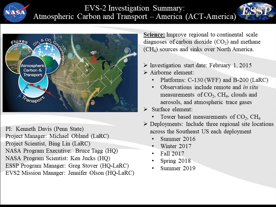
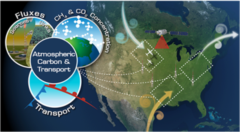
Top Menu

NASA logo
TAP

Archive | Completed Missions RSS

Aquarius

Acquarius

Aquarius

https://aquarius.nasa.gov/

The joint U.S./Argentinian Aquarius/Satélite de Aplicaciones Científicas (SAC)-D mission was launched June 10, 2011, and ended on June 8, 2015, when an essential part of the power and attitude control system for the spacecraft stopped operating. The Aquarius instrument successfully achieved its science objectives and completed its primary three-year mission in November 2014.

Aquarius/SAC-D mapped the salinity (the concentration of dissolved salt) at the ocean surface, information critical to improving our understanding of two major components of Earth’s climate system: the water cycle and ocean circulation. By measuring ocean salinity from space, Aquarius provided new insights into how the massive natural exchange of freshwater between the ocean, atmosphere and sea ice influences ocean circulation, weather and climate.

Aquarius/SAC-D mapped the salinity (the concentration of dissolved salt) at the ocean surface, information critical to improving our understanding of two major components of Earth’s climate system


ACT America

Atmospheric Carbon and Transport-America
(ACT-America)

https://act-america.larc.nasa.gov/
https://blogs.nasa.gov/earthexpeditions/tag/act-america/

Flying with the gases that impact the climate around you. Making the invisible journey visible.

Track carbon footprints across the sky and through four seasons!
ACT-America is on the hunt for greenhouse gases from our ground and in our air. The project measured both natural and human-based methane (CH4) and carbon dioxide (CO2) to identify how these gases are created, where they go and what absorbs them. Understanding the carbon cycle is powerful knowledge. It means we can predict future climate impacts, develop smarter mitigation strategies, and create fact-based policy. Imagine the benefit from “seeing” where these invisible gases are coming from and where they go.

“ACT-America measurements fill a critical gap in our understanding of the sources, sinks and transport of climate-altering greenhouse gasses. We now see how weather stirs the atmosphere and mixes these gasses across the continent, like a large spoon mixing the cream in your coffee.” – Ken Davis, Principal Investigator

The ACT-America investigation featured five seasonal aircraft campaigns spread over three years, across the eastern and central regions of the United States. Instruments aboard a NASA C-130 and a NASA B-200 aircraft measured greenhouse gasses and indicators of the origins of these greenhouse gases and tracked how weather systems transport them. The aircraft data are part of a growing network of observations that will track the “footprints” of greenhouse gases to enable: 1) policy makers, citizens and industry to understand how their actions are changing the earth’s climate; 2) knowledge of natural gas leaks and awareness of opportunities to minimize these losses; 3) how the earth’s ecosystems contribute to the carbon cycle; and 4) accurate forecasting of future climate. ACT-America’s data can be found here.

https://www.youtube.com/watch?v=c76TfzEJLPo

Related Projects

ACT-America measurements fill a critical gap in our understanding of the sources, sinks and transport of climate-altering greenhouse gasses. We now see how weather stirs the atmosphere and mixes these gasses across the continent, like a large spoon mixing the cream in your coffee.


AirMOSS

Airborne Microwave Observatory of Subcanopy and Subsurface (AirMOSS)

https://airmoss.jpl.nasa.gov/

The Hurricane and Severe Storm Sentinel (HS3) is a five-year mission specifically targeted to investigate the processes that underlie hurricane formation and intensity change in the Atlantic Ocean basin. HS3 is motivated by hypotheses related to the relative roles of the large-scale environment and storm-scale internal processes.

ATTREX

Despite its low concentration, stratospheric water vapor has large impacts on the earth’s energy budget and climate. Recent studies suggest that even small changes in stratospheric humidity may have climate impacts that are significant compared to those of decadal increases in greenhouse gases. Future changes in stratospheric humidity and ozone concentration in response to changing climate are significant climate feedbacks.

Atmospheric Tomography Mission (ATOM)

Atmospheric Tomography Mission (ATOM)

Come journey with us and see your impact on the earths’ atmosphere! Can we slow global warming and improve air?

Atom studies the impact of human-produced air pollution on greenhouse gasses and the atmosphere. Pollution changes the air we are breathing right now. This is powerful information for improving our current and future air quality. It helps policy makers with actionable facts and informs modified behavior. We can actually measure our combined impact.​

NASA’s AToM has a flying laboratory aboard the DC-8 aircraft. 42 scientists and operations crew flew with AToM on a 26-day journey from nearly pole to pole and back again. They measured more than 200 gases and airborne particles from the remotest parts of the atmosphere and learned how various greenhouse gases cycle around the world. Atom shows how it’s all one interconnected atmosphere no matter where in the world you are!​

Atom studies the impact of human-produced air pollution on greenhouse gasses and the atmosphere. Pollution changes the air we are breathing right now. This is powerful information for improving our current and future air quality. It helps policy makers with actionable facts and informs modified behavior. We can actually measure our combined impact


[fourcol_six]

CARVE

The carbon budget of Arctic ecosystems is not known with confidence since fundamental elements of the complex Arctic biological-climatologic-hydrologic system are poorly quantified. CARVE collected detailed measurements of important greenhouse gases on local to regional scales in the Alaskan Arctic and demonstrated new remote sensing and improved modeling capabilities to quantify Arctic carbon fluxes and carbon cycle-climate processes.

CORAL

CORAL

COral Reef Airborne Laboratory (CORAL)


https://www.nasa.gov/content/earth-expeditions-coral
https://coral.jpl.nasa.gov/

The three-year COral Reef Airborne Laboratory (CORAL) mission will survey a portion of the world’s coral reefs to assess the condition of these threatened ecosystems and understand their relation to the environment, including physical, chemical and human factors. CORAL will use advanced airborne instruments, including the Portable Remote Imaging Spectrometer (PRISM), and in-water measurements. The investigation will assess the reefs of Palau, the Mariana Islands, portions of Australia’s Great Barrier Reef and Hawaii beginning in 2016. With new understanding of reef condition, the future of this global ecosystem can be predicted.

The three-year COral Reef Airborne Laboratory (CORAL) mission will survey a portion of the world’s coral reefs to assess the condition of these threatened ecosystems and understand their relation to the environment, including physical, chemical and human factors.


DISCOVER-AQ

DISCOVER-AQ was a four-year campaign to improve the use of satellites to monitor air quality for public health and environmental benefit.

EPOCH

EPOCH logo

East Pacific Origins and Characteristics of Hurricanes (EPOCH)


Over the past five years, tropical activity in the East
Pacific has increased, while decreasing in the Atlantic Basin. In addition, during El Niño years, warmer than average sea surface 5 temperatures further increase
the likelihood of tropical cyclone formation in the East Pacific. EPOCH plans to fly the AV-6 GH aircraft with the EXRAD radar, the High Altitude MMIC Sounding Radiometer (HAMSR), and the NOAA AVAPS dropsonde system to investigate genesis and rapid intensification (RI) of an East Pacific hurricane by measuring both the environment and interior structures.

EPOCH will develop the EXRAD radar from a Technical Readiness Level 6, with respect to the Global Hawk, to a Technical Readiness Level 8 at the end of the project with a successful flight of the radar, radiometer, and dropsondes over an East Pacific hurricane.


GRACE

GRACE

Gravity Recovery and Climate Experiment (GRACE)


https://www.jpl.nasa.gov/missions/gravity-recovery-and-climate-experiment-grace/

An award-winning mission that’s changed the way we study Earth’s gravitational forces and the Earth system, the Gravity Recovery and Climate Experiment, or GRACE, mission flew twin spacecraft in tandem around Earth to study key changes in the planet’s waters, ice sheets and the solid Earth.

In 2011, the gravity measurement technique pioneered by GRACE, which works by measuring changes in the push and pull between the twin spacecraft as they orbit Earth, was put to use on NASA’s twin GRAIL spacecraft embarking on an ambitious mission to study the gravitational forces of Earth’s moon.

In more than 15 years of operations, the GRACE satellite mission revolutionized our view of how water moves and is stored on Earth.

An award-winning mission that’s changed the way we study Earth’s gravitational forces and the Earth system, the Gravity Recovery and Climate Experiment, or GRACE, mission flew twin spacecraft in tandem around Earth to study key changes in the planet’s waters, ice sheets and the solid Earth.


Powered by WordPress. Designed by WooThemes