Top Menu

NASA logo
TAP

Archive | Active Missions RSS

INCUS

INCUS

INCUS


The INCUS Mission

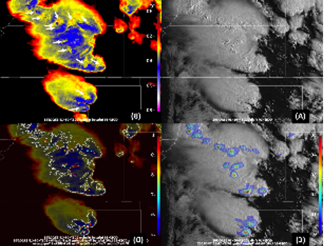
The INCUS mission provides the first tropics-wide investigation of the evolution of the vertical transport of air and water by convective storms, one of the most influential, yet unmeasured atmospheric processes. Such measurements are central to improving our capability to better predict extreme weather events and their changes with warming climates.

https://incus.colostate.edu/

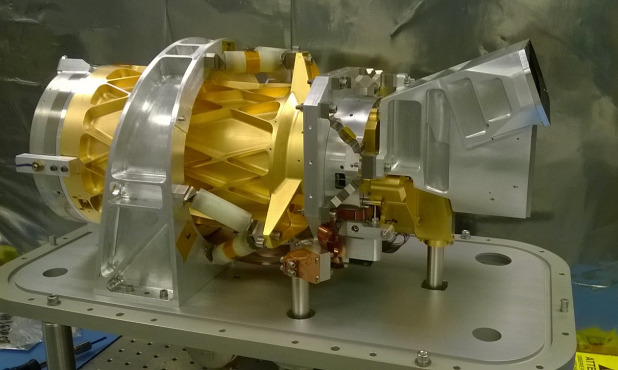
The Investigation of Convective Updrafts (INCUS) mission will be a collection of three SmallSats, carrying RainCube-like radars with crosstrack scanning and a Tempest-D-like radiometer, flying in tight coordination. INCUS aims to directly address why convective storms, heavy precipitation, and clouds occur exactly when and where they form. The investigation stems from the 2017 Earth Science Decadal Survey by the National Academies of Sciences, Engineering, and Medicine, which lays out ambitious, but critically necessary, research and observation guidance. NASA selected INCUS through the agency’s Earth Venture Mission-3 (EVM-3) solicitation that sought complete, space-based investigations to address important science questions and produce data of societal relevance within the Earth science field..


ACTIVATE

Aerosol Cloud meTeorology Interactions oVer the western ATlantic Experiment (ACTIVATE)

https://activate.larc.nasa.gov/

Riding the marine layer skies looking for aerosol particles – to predict future climate change.

Simulate climate and predict change as it happens!

NASA’s ACTIVATE mission is on the hunt for clouds off the coast over the western Atlantic Ocean! It is looking for answers to help us understand how clouds and aerosols (particles in the air) affect light and heat from the sun. The size and number of cloud droplets within a cloud determines things like how long the cloud lasts, how well it traps heat at the earth’s surface, or how well it reflects sunlight. All of these can have a significant impact on the earth’s climate. One of the largest unknowns in climate change is how the interaction between clouds and aerosols impacts the climate and understanding this is critical towards improving predictions of how future climate will be impacted by human emissions.

“Climate change is one of the most pressing issues we are facing on this planet; it is important for all regions of the world. I have spent my research career studying aerosol particles and the extension to how these particles interact with clouds has opened up a whole new avenue of greater challenges that entices me. The research involves using airborne platforms, which has always been of interest to me as I have always been drawn to airplanes.” – Armin Sorooshian, Principal Investigator

NASA’s ACTIVATE investigation is a five-year project studying how clouds and aerosols interact. Aerosols are very tiny particles that are suspended in the atmosphere and are often the “seed that cloud droplets form around. ACTIVATE focuses on marine boundary layer (MBL) clouds off of the east coast of North America. This region sees a large source of aerosols transported from the US eastern seaboard, making it an ideal area to study these interactions. ACTIVATE is aiming to collect a dataset on aerosol and cloud interactions of unprecedented size and statistics. What’s unique about this investigation? NASA Langley’s King Air and the HU-25A Falcon aircraft are flying together in coordinated patterns to simultaneously gather data from well above the clouds and from directly within the vicinity of the cloud deck itself. These data for both aerosols and clouds will give scientists better understanding as to how these mediums interact and affect our climate.

Related Projects

CALIPSO

NAAMESlogo

NAAMES

ORACLES

ORACLES

NASA’s ACTIVATE mission is on the hunt for clouds off the coast over the western Atlantic Ocean! It is looking for answers to help us understand how clouds and aerosols (particles in the air) affect light and heat from the sun.


CALIPSO

Cloud-Aerosol Lidar and Infrared Pathfinder Satellite Observation (CALIPSO)


https://www-calipso.larc.nasa.gov/
https://www.nasa.gov/mission_pages/calipso/main/index.html

The CALIPSO satellite provides new insight into the role that clouds and atmospheric aerosols play in regulating Earth’s weather, climate, and air quality.

CALIPSO combines an active lidar instrument with passive infrared and visible imagers to probe the vertical structure and properties of thin clouds and aerosols over the globe. CALIPSO was launched on April 28, 2006, with the CloudSat satellite.

CALIPSO and CloudSat are highly complementary and together provide new, never-before-seen 3D perspectives of how clouds and aerosols form, evolve, and affect weather and climate. CALIPSO and CloudSat fly in formation with three other satellites in the A-train constellation to enable an even greater understanding of our climate system.

The CALIPSO satellite provides new insight into the role that clouds and atmospheric aerosols play in regulating Earth’s weather, climate, and air quality.

CloudSat

CloudSat2 

CloudSat

https://cloudsat.atmos.colostate.edu/home

https://cloudsat.atmos.colostate.edu/data


CloudSat is one of NASA’s weather and climate-tracking satellites, and from its name, it’s apparent what it measures – clouds!! Clouds have an enormous influence on Earth’s weather, climate and energy balance, and CloudSat has been helping scientists learn about clouds since it was launched on a Delta II rocket in 2006. From providing a view from space as we watch an approaching hurricane to providing details about how clouds impact radiation from the sun and the climate, CloudSat has been understanding the impact of clouds for nearly 15 years.

The cloud radar on CloudSat is 1000 times more sensitive than most weather radars on the ground. With its long history sending us data about clouds, CloudSat has contributed so much valuable information! CloudSat provides a never-before-seen perspective on clouds; its radar allows us to see inside the large cloud masses that make our weather. This helps us understand processes such as those that convert the tiny cloud particles to precipitation. Key discoveries from CloudSat have included how often the clouds above Earth rain and snow, how much ice and water are in clouds, and how clouds heat or cool the atmosphere. Cloudsat measurements have shown how pollution, volcanic ash, and other aerosols can interact with clouds and affect both precipitation and how efficiently clouds reflect sunlight, which has a huge impact on climate. The cloud and precipitation measurements from CloudSat have been used to track the intensity and patterns of tropical cyclones as they become hurricanes. All of these critical observations will ultimately help us predict the effects of clouds on our climate and improve our predictions of climate change.

NASA launched the CloudSat and the Cloud-Aerosol Lidar and Infrared Pathfinder Satellite Observation (CALIPSO) spacecraft to study the role that clouds and aerosols play in regulating Earth’s weather, climate and air quality.


CYGNSS

Cyclone Global Navigation Satellite System (CYGNSS)

A new constellation in space is telling us how hurricanes and floods are threatening us on Earth

https://www.nasa.gov/cygnss

  On December 15, 2016, an aircraft called “Stargazer” took off from Cape Canaveral, Florida and flew a hundred miles or so off the coast. During flight, a rocket was launched from the aircraft carrying eight NASA micro-satellites into space called Cyclone Global Navigation Satellite System (CYGNSS). The CYGNSS microsatellites are currently orbiting the tropics about 315 miles up. CYGNSS is used to measure winds in tropical storms and hurricanes. Since it can “see” the winds inside the storms and at the surface of the ocean, CYGNSS is able to improve predictions of how strong hurricanes will get and where they will make landfall. Not only is CYGNSS looking at the ocean, it is also studying moisture levels in the land. These soil moisture measurements can improve predictions of soil saturation, rain runoff and flooding. This data helps keep people who live in coastal areas safe from hurricane disasters and helps them plan better communities to combat future storms.

“It is very gratifying to see the potential CYGNSS has to make useful, practical contributions to people’s everyday lives by improving forecasts of storms and floods.” – Chris Ruf, PI, CYGNSS

The technology on each of the CYGNSS microsatellites is something familiar – a GPS! When CYGNSS sends GPS radio signals to the earth and they are bounced off of ocean waves, the signal that is reflected back to the satellite tells us what the winds are like right at the ocean surface. Since it was launched in 2016, scientists have been learning how to use CYGNSS data in many other ways too. It is able to show us flooded areas on land – during Hurricane Harvey, CYGNSS was used to identify the spread of the flooding over the Houston area. This helps “first responders” know which areas need urgent help during flooding disasters. Recently, CYGNSS has been used to help locate areas of a major locust outbreak in East Africa. CYGNSS satellites may be micro-sized, but they have a huge role in helping us better understand hurricanes, flooding, and locusts.

The Cyclone Global Navigation Satellite System (CYGNSS) will probe the inner core of hurricanes to learn about their rapid intensification.

DCOTSS

Dynamics and Chemistry of the Summer Stratosphere (DCOTSS)

https://dcotss.org/

DCOTSS Outreach

During the summer, strong convective storms over North America overshoot the tropopause into the lower stratosphere. These storms carry water and pollutants from the troposphere into the normally very dry stratosphere, where they can have a significant impact on radiative and chemical processes, potentially including stratospheric ozone. The photo below, taken from the International Space Station, shows one of these storms with an anvil, which is typically near the tropopause level; an overshooting top; and a plume of cirrus (ice) clouds injected into the stratosphere by the overshooting top. Overshooting tops can reach many kilometers above the tropopause into the stratosphere.
During the summer, strong convective storms over North America overshoot the tropopause into the lower stratosphere. These storms carry water and pollutants from the troposphere into the normally very dry stratosphere, where they can have a significant impact on radiative and chemical processes, potentially including stratospheric ozone.
[/fourcol_six]

Delta-X

Delta-X

Delta-X – Forecasting the fate of the Mississippi River Delta

Mississippi Delta is in peril with the livelihood of millions in jeopardy
“Good Lord’s willing, and the creek don’t rise.” Johnny Cash

Simulate climate and predict change as it happens!

Deltas everywhere provide many benefits to life on earth – like serving as a natural protection for our cities and towns against storm surges and tsunamis, or being wetland habitats for crustaceans, mammals, and birds. Many deltas are home to large cities, and people depend on the wetlands for their livelihoods. Deltas around the world, however, are in peril! They’re drowning due to sea level rise and lack of sediment deposited by rivers; it is expected that nearly all of the world’s major river deltas are at risk of drowning this century. The natural influx of sediments from upstream would naturally build up the deltas and provide resilience to sea level rise, however, river channels delivering the sediments have been disrupted by human activities.

“We hope Delta-X calibrated hydrodynamic models will support other agencies and stakeholders in planning coastal
restoration projects and managing resources in the Mississippi River Delta.” – Marc Simard, Delta-X Principal Investigator

NASA’s Delta-X project seeks to understand how parts of the Mississippi River Delta (MRD) are growing and others are sinking. Due to a combination of factors (sea level rise; the disruption of sedimentation; a general sinking of the land due to natural compaction, underground extraction of oil, gas, and water), the Louisiana coastline has been losing land at the rate of almost one football field every hour during the last few decades! Delta-X scientists will collect data over the Atchafalaya and Terrebonne basins during two deployments in 2021 using state of the art remote sensing instruments onboard three aircraft and using in-situ (direct) instruments deployed across the basins. The Delta-X scientists will use this data to learn how and where the MRD is gaining and losing land. The data will be used to improve and calibrate models that predict how the MRD will respond to continuing sea level rise over the next century and to identify which areas are the most vulnerable to sea level rise and storms.

https://www.youtube.com/watch?v=I0oAkijxj-E#action=share
https://www.jpl.nasa.gov/news/news.php?feature=7601
https://www.youtube.com/watch?v=beeD3GRTkpQ

Deltas everywhere provide many benefits to life on earth – like serving as a natural protection for our cities and towns against storm surges and tsunamis, or being wetland habitats for crustaceans, mammals, and birds.


ECOSTRESS

ECOSTRESS

ECOsystem Spaceborne Thermal Radiometer Experiment on Space Station (ECOSTRESS)


https://www.nasa.gov/mission_pages/ecostress
https://ecostress.jpl.nasa.gov/

NECOSTRESS will provide critical insight into plant-water dynamics and how ecosystems change with climate via highspatiotemporal resolution thermal infrared radiometer measurements of evapotranspiration (ET) from the
International Space Station (ISS). ECOSTRESS will:
• Identify critical thresholds of water use and water stress in key climate-sensitive biomes
• Detect the timing, location, and predictive factors leading to plant water uptake decline and/or cessation over the diurnal cycle
• Measure agricultural water consumptive use over the contiguous United States (CONUS) at spatiotemporal scales applicable to improve drought estimation accuracy.
The ECOSTRESS mission is answering these questions by accurately measuring the temperature of plants. Plants regulate their temperature by releasing water through tiny pores on their leaves called stomata. If they have sufficient water they can maintain their temperature, but if there is insufficient water, their temperatures rise and this temperature rise can be measured with ECOSTRESS. The images acquired by ECOSTRESS are the most detailed temperature images of the surface ever acquired from space and can be used to measure the temperature of an individual farmers field.
One of the core products that will be produced by ECOSTRESS team is the Evaporative Stress Index (ESI). ESI is a leading drought indicator – it can indicate that plants are stressed and that a drought is likely to occur providing the option for decision makers to take action.

Click here for Data Access https://e4ftl01.cr.usgs.gov/ECOSTRESS/

ECOSTRESS data can indicate when plants are stressed and that a drought is likely to occur providing the option for decision makers to take action.


[fourcol_six]

EMIT

EMIT logo

EMIT (Earth Surface Mineral Dust Source Investigation)

EMIT Project Website

Discovering what mineral dust is made of and if it cools or warms our atmosphere

What is in the mineral dust that that can travel from Africa to Texas and why do people care so much?

In June 2020 mineral dust blew from the surface of Africa and arrived in the southern United States impacting states from Florida to Texas. It created visibility hazards for people and had other impacts to our environment. Clearly, our world is interconnected by air, land, and water, but what is the journey of the dust and how does it impact us? The NASA Earth Surface Mineral Dust Source Investigation (EMIT) is studying the composition of the Earth’s mineral dust regions and how it impacts our planet and people (radiative forcing, atmospheric chemistry, cryosphere melt, ocean biogeochemistry, fertilization of terrestrial ecosystems, as well as hazards and toxicity to human populations). By measuring the source regions and using sophisticated models, EMIT will assess current mineral dust heating and cooling impacts to the Earth and predict potential future changes, enabling scientists to better understand the role of mineral dust in the Earth System that we all live within.

“The time for EMIT is now. Minerals dust has impacts throughout the Earth System. Only now is the advanced NASA technology available for the EMIT instrumentation. Only now are the modern Earth System Models ready for EMIT type initialization. With EMIT we can better understand how mineral dust heats and cools our planet and make decisions regarding how to accommodate and/or mitigate these impacts.” – Robert O. Green, Principal Investigator, EMIT

Mineral dust blown into the atmosphere has many effects on the Earth System including heating and cooling. These first-of-their-kind EMIT measurements will help us understand and make decisions regarding these impacts. How? The EMIT imaging spectrometer instrument is the next generation based on NASA’s Moon Mineralogy Mapper that mapped minerals and discovered water on the illuminated surface of the Moon. EMIT’s instrument will be mounted to the exterior of the International Space Station to measure the composition of mineral dust source regions around the world. EMIT’s state-of-the-art imaging spectrometer measures the different wavelengths of light reflected by minerals on the surface of deserts and other dust sources. The EMIT science team uses these mineral spectroscopic “fingerprints” in conjunction with advanced Earth System models to achieve its objectives. By measuring in detail which minerals make up the dust, EMIT is helping answer the essential question – to what extent does this type ofaerosol warm or cool the atmosphere?. This helps us to better understand what’s happening to our atmosphere now and predict how things may change in the future. The output of EMIT has both economic and public benefit for you (e.g. natural resources and hazard mitigation). You will be able to access the EMIT measurements and products at NASA’s Land Processes Distributed Active Archive Center.

The Earth Surface Mineral Dust Source Investigation (EMIT) is an Earth Ventures-Instrument (EVI-4) Mission to map the surface mineralogy of arid dust source regions via imaging spectroscopy in the visible and short-wave infrared (VSWIR).


GEDI

GEDI

Global Ecosystem Dynamics Investigation (GEDI)

Data from NASA’s Global Ecosystem Dynamics Investigation (GEDI) mission are adding to our understanding of carbon cycling and the structure and development of global biomes.

From red angelim trees in the Amazon towering hundreds of feet above the ground to clusters of shrubs hugging the surface, terrestrial biomes develop in height and density as well as in length and width. Data depicting this three-dimensional structure, however, are limited. This gap is being filled with several recently-launched Earth observing missions. The first data from one of these missions—NASA’s Global Ecosystem Dynamics Investigation (GEDI)—are now publicly available through NASA’s Land Processes Distributed Active Archive Center (LP DAAC).

Launched on December 5, 2018, and installed on the International Space Station’s Japanese Experiment Module-Exposed Facility (JEM-EF), GEDI is led by a science team at the University of Maryland in collaboration with NASA’s Goddard Space Flight Center in Greenbelt, Maryland. As noted on the GEDI mission website, data are initially transferred to the GEDI Mission Operations Center (MOC) and then processed through the Science Operations Center (SOC), both of which are located at Goddard. Its primary two-year mission is to produce high-resolution laser ranging observations of Earth in order to characterize the effects of climate change and land use on ecosystem structure and dynamics.

Data from NASA’s Global Ecosystem Dynamics Investigation (GEDI) mission are adding to our understanding of carbon cycling and the structure and development of global biomes.


Powered by WordPress. Designed by WooThemes